An Cróicín, Geata an Phortaigh & Cuainín an Mhúin – cad as a dtagann na hainmneacha seo agus cad is brí leo? Tá an Léarscáil Logainmneacha mar thoradh ar níos mó ná 10 mbliana ag obair le páistí i mBunscoileanna Phort Láirge ag fiosrú logainmneacha chun na ceisteanna seo a fhreagairt.
The Black Boreen, The Sgilloges and The Duck’s Walk – where did these names come from and what do they mean? The Placenames Map is the result of more than 10 years of working with children in Waterford Primary Schools exploring placenames to answer those questions.

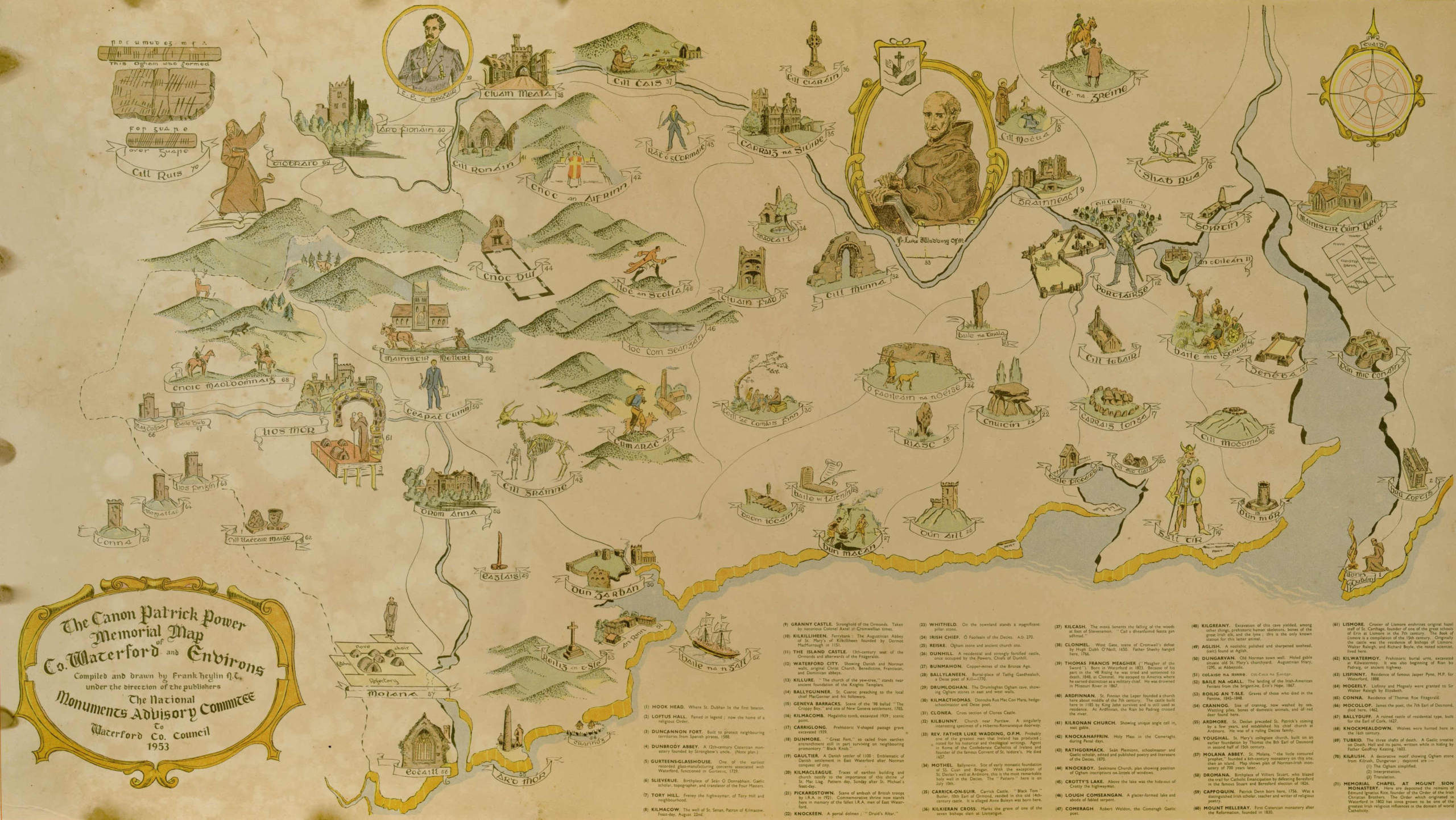
Tugann an léarscáil seo mór-léargas ar shuíomhanna na logainmneacha.
This map gives an overview of the locations of the placenames.

Le haghaidh amharc ón aer agus taiscéalaíocht níos fairsinge cliceáil anseo.
For an aerial view and a more extensive exploration please click here.
Le maoiniú ó Phort Láirge Ildánach, tá Léarscáil Scéala ar líne forbartha againn chun na logainmneacha atá bailithe ag scoileanna rannpháirteacha thar na blianta a roinnt. Léiríonn an léarscáil suíomh gach logainm agus tá an bhileog oibre ón dalta ceangailte leis, ina dtugtar eolas faoin logainm agus foinse na faisnéise a cuireadh ar fáil. Táimid buíoch dos na múinteoirí agus na daltaí ó na 24 scoil a ghlac páirt sa tionscadal go dtí seo (Samhradh 2023) agus ba mhaith linn ár mbuíochas a ghabháil leo as a gcuid oibre crua. Tá súil againn go mbainfidh siad taitneamh as torthaí a gcuid oibre a fheiceáil.
With funding from Creative Waterford, we have developed an online Storymap to share the placenames that have been gathered by participating schools over the years. The map identifies the location of each placename and includes the worksheet from the pupil giving information about the placename and the source of the information provided. We are grateful to all the teachers and pupils from the 24 schools who have taken part in the project to date (Summer 2023) and would like to thank them for their hard work. We hope that they enjoy exploring the results of their work.
Léiríonn na logainmneacha an oidhreacht shaibhir agus an ceangal leis an talamh i bPort Láirge. Tá ainmneacha go leor de na réimsí sin ina n-ábhar fíorais; ‘An Pháirc Mhór’, ‘Páirc na Cairéal’ srl, ach tugann ainmneacha eile léargas níos fearr dúinn ar stair na páirce, m.sh. ‘Páircín an Rince’, ‘Páirc an Átha’ srl. Trí na hainmneacha a mhapáil, feicimid focail choitianta atá in úsáid ar fud an chontae agus leid ar an obair chrua a bhain leis an bhfeirmeoireacht, le focail ar nós “carraig” agus “cloch” mar ghnéithe coitianta sna logainmneacha.
The placenames gathered show the rich heritage and connection to the land in Waterford. The names of many of the fields are matter of fact; ‘The Big Field’, ‘The Quarry Field’ etc, but others give us a greater insight into the history of the field, e.g. ‘The Dancing Field’, ‘The Fort Field’ etc. By mapping the names, we can also see common words being used across the county and a hint of the hard work involved in farming, as “rock” and “stone” feature heavily in the names.
Leanfaimid orainn ag obair le scoileanna agus le pobail áitiúla chun ár logainmneacha áitiúla a mhapáil agus a dhoiciméadú agus chun an oidhreacht shaibhir seo a roinnt. Tugaimid cuireadh duit taitneamh a bhaint as logainmneacha Phort Láirge a iniúchadh.
We will continue to work with schools and local communities to map and document our local placenames and share this rich heritage. We invite you to enjoy exploring Waterford’s placenames.
Nóta Cóipchirt
Baineann an cóipcheart dos na léarscáileanna agus na haerghriangraif a úsáidtear sna bileoga oibre agus mar bhunús an Léarscáil Scéala le:
Léarscáileanna: © Suirbhéireacht Ordanáis Éireann. Gach ceart ar cosaint. Uimhir an cheadúnais 2014/18/CCMA/WaterfordCity&CountyCouncil.
Aerghrianghraif: Poblacht na hÉireann RGB & CIR — © Bluesky International Ltd.
Is as an leabhar Fír Mhora an tSean-Phobail an léarscáil a úsáidtear i mbileoga oibre do logainmneacha an tSean-Phobail, foilsithe ag Coláiste na Rinne, 2002 agus tá sí faoi chóipcheart agus foilsithe le cead ón nGúm.
Cuimsíonn iontráil Bharra na Stuaic alt dar teideal “Irish Cresset Stones” le Michael Moore in imleabhar JRSAI 114 1984, leathanaigh 98-116 agus déantar é a fhoilsiú le cead ón údar.
Táimid fíorbhuíoch as an gcead chun na léarscáileanna seo a roinnt mar chuid den tionscadal.
Copyright Note
The maps and aerial photographs used in the worksheets and underlying the Storymap are copyright to:
Maps: © Ordnance Survey Ireland. All rights reserved. License number 2014/18/CCMA/WaterfordCity&CountyCouncil.
Aerial Photos: Republic of Ireland RGB & CIR – © Bluesky International Ltd.
The map used in worksheets for placenames in An Sean Phobail is from the book Fír Mhora an tSean-Phobail, published by Coláiste na Rinne, 2002 and is copyright to and published with permission from An Gúm.
The entry for Barranastook includes an article “Irish Cresset Stones” by Michael Moore in the JRSAI volume 114 1984 pages 98-116 and is reproduced with permission from the author.
We are very grateful for the permission to share these maps as part of the project.

Is ceart ceisteanna maidir le Tionscadal Logainmneacha na Scoileanna a chur ar aghaidh chuig Cartlannaí an Chontae:
Joanne Rothwell:
Teil: 0761-10-2144
R-Phost: jrothwell@waterfordcouncil.ie
Is ceart ceisteanna maidir le Coiste Logainmneacha Phort Láirge a chur ar aghaidh chuig an tOifigeach Gaeilge:
Máire Seosaimhín Breathnach:
Teil: 0761-10-1884
R-Phost: msbreathnach@waterfordcouncil.ie